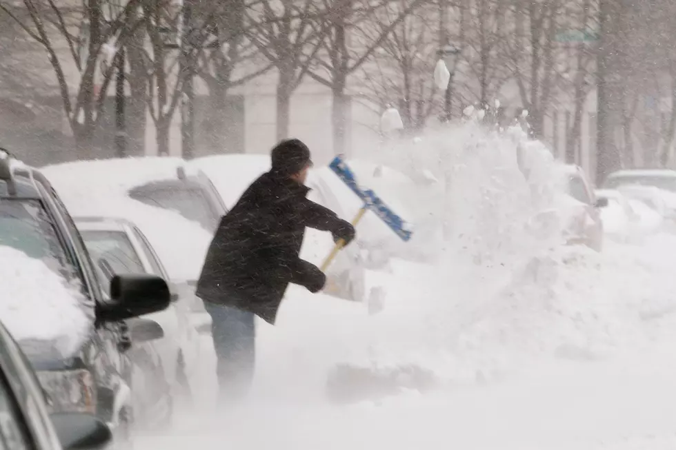
Winter Weather Advisories Issued for Lubbock, South Plains, Texas Panhandle, and Permian Basin
We're now less than 18 hours away from the start of the first winter storm of 2022.
Multiple Winter Weather Advisories were issued Tuesday afternoon (February 1st) covering Lubbock, the South Plains, Amarillo and the Texas Panhandle, and the Permian Basin. Two separate Winter Weather Advisories were also issued for Lubbock and the South Plains.

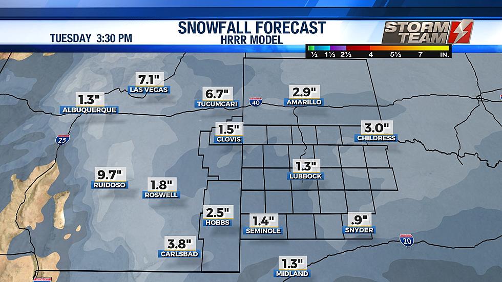
Tuesday afternoon, Ron Roberts revised his snowfall forecast for Lubbock and the South Plains, and it matches up for the most part with the National Weather Service's forecasts.
The first Winter Weather Advisory starts at 6 a.m. on Wednesday for Crosby County and South Plains counties to the east of Crosbyton. 1 to 3 inches of snowfall is forecast along with icy road conditions for Wednesday night and Thursday morning. The second Winter Weather Advisory is for Lubbock and Lubbock County, along with all South Plains counties to the west and north of Lubbock. 1 to 3 inches of snowfall is forecast, along with icy road conditions for Wednesday night and Thursday morning.
URGENT - WINTER WEATHER MESSAGE
National Weather Service Lubbock TX
437 PM CST Tue Feb 1 2022

Motley-Cottle-Crosby-Dickens-King-Garza-Kent-Stonewall-
Including the cities of Old Glory, Roaring Springs, Paducah,
Spur, Cee Vee, Guthrie, Aspermont, Jayton, Ralls, Lake Alan
Henry, Dickens, Dumont, Post, Crosbyton, and Matador
437 PM CST Tue Feb 1 2022

...WINTER WEATHER ADVISORY IN EFFECT FROM 6 AM WEDNESDAY TO 6 PM CST
THURSDAY...

* WHAT...Mixed precipitation expected. Total snow and sleet
  accumulations between 1 and 3 inches and ice accumulations less
  than one tenth of an inch. Winds gusting as high as 35 mph.

* WHERE...Cottle, Crosby, Dickens, Garza, Kent, King, Motley and
  Stonewall Counties.

* WHEN...From 6 AM Wednesday to 6 PM CST Thursday.

* IMPACTS...Plan on slippery road conditions. The hazardous
  conditions could impact the Wednesday morning and evening commutes.

PRECAUTIONARY/PREPAREDNESS ACTIONS...

Slow down and use caution while traveling. The latest road
conditions for the state you are calling from can be obtained by
calling 5 1 1.
URGENT - WINTER WEATHER MESSAGE
National Weather Service Lubbock TX
437 PM CST Tue Feb 1 2022

Parmer-Castro-Swisher-Briscoe-Hall-Childress-Bailey-Lamb-Hale-
Floyd-Cochran-Hockley-Lubbock-Yoakum-Terry-Lynn-
Including the cities of Turkey, Tulia, Silverton, Lubbock,
Plains, Muleshoe, Whiteface, Denver City, Kirkland, Happy,
Wolfforth, Quitaque, Lockney, ODonnell, New Home, Friona, Olton,
Hale Center, Memphis, Sundown, Farwell, Childress, Slaton,
Littlefield, Wellman, Plainview, Dimmitt, Hart, Meadow,
Brownfield, Bovina, Floydada, Tahoka, Levelland, Amherst, and
Morton
437 PM CST Tue Feb 1 2022

...WINTER WEATHER ADVISORY IN EFFECT FROM NOON WEDNESDAY TO 6 PM CST
THURSDAY...

* WHAT...Snow expected. Total snow accumulations between 1 and 3
  inches.

* WHERE...The South Plains and the extreme southern Texas Panhandle.

* WHEN...From Noon Wednesday to 6 PM CST Thursday.

* IMPACTS...Plan on slippery road conditions. The hazardous
  conditions could impact the Wednesday evening and Thursday morning
  commutes.

PRECAUTIONARY/PREPAREDNESS ACTIONS...

Slow down and use caution while traveling. The latest road
conditions for the state you are calling from can be obtained by
calling 5 1 1.
The Winter Weather Advisory for the Texas Panhandle starts at 9 p.m. on Tuesday night, February 1st and continues through 6 p.m. on Thursday, February 3rd. The Amarillo area is expected to receive between 2 to 4 inches of snow.
URGENT - WINTER WEATHER MESSAGE
National Weather Service Amarillo TX
220 PM CST Tue Feb 1 2022

Dallam-Sherman-Hansford-Ochiltree-Lipscomb-Hartley-Moore-
Hutchinson-Roberts-Hemphill-Oldham-Potter-Carson-Gray-Wheeler-
Deaf Smith-Randall-Armstrong-Donley-Collingsworth-Palo Duro
Canyon-
Including the cities of Lake Marvin, Lutie, Dalhart, Claude,
Wheeler, Glazier, Romero, Umbarger, Conlen, Canadian, Twitty,
Lora, Pampa, Gruver, Goodnight, Clarendon, Lela, Four Way,
Borger, Codman, Canyon, Amarillo, Waka, Perryton, Samnorwood,
Buffalo Lake, Panhandle, Ware, Boys Ranch, Bootleg, Dozier,
Higgins, Masterson, Miami, White Deer, Wellington, Vega, Booker,
Wolf Creek Park, Palo Duro Canyon State Park, Pantex, Washburn,
Bushland, Spearman, Channing, Kingsmill, Farnsworth, Wayside,
Briscoe, Skellytown, Dumas, Shamrock, Wildorado, Stratford,
Follett, Hereford, Dawn, and Hartley
220 PM CST Tue Feb 1 2022

...WINTER WEATHER ADVISORY REMAINS IN EFFECT FROM 9 PM THIS EVENING
TO 6 PM CST THURSDAY...

* WHAT...Snow expected. Total snow accumulations between 2 and 4
  inches.

* WHERE...The Texas Panhandle.

* WHEN...From 9 PM this evening to 6 PM CST Thursday.

* IMPACTS...Roads, and especially bridges and overpasses, will
  likely become slick and hazardous.

* ADDITIONAL DETAILS...Wind chills Thursday morning may drop below
  minus 15 degrees, particularly in the northern Texas Panhandle.

PRECAUTIONARY/PREPAREDNESS ACTIONS...

Be prepared for slippery roads. Slow down and use caution while
driving. If you are going outside, watch your first few steps taken
on stairs, sidewalks, and driveways. These surfaces could be icy and
slippery, increasing your risk of a fall and injury.
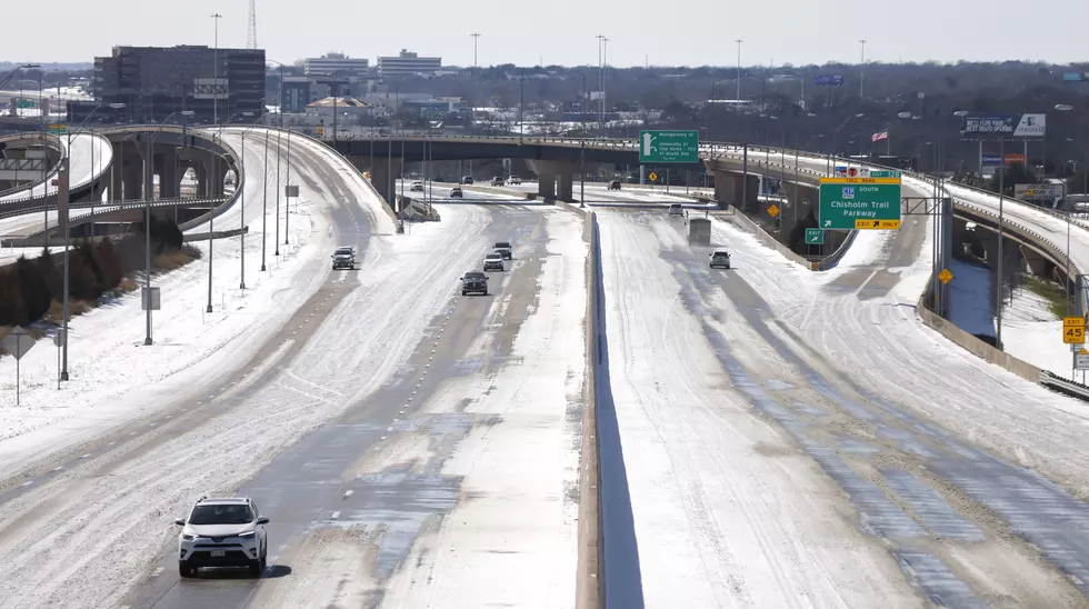
Finally, the Winter Weather Advisory for Big Spring, Midland, Odessa and the rest of the Permian Basin starts at noon on Wednesday, February 2nd. The NWS forecast still calls for a higher amount of snow, between 1 to 4 inches, plus the possibility of hazardous driving conditions on both I-20 and I-10.
URGENT - WINTER WEATHER MESSAGE
National Weather Service Midland/Odessa TX
245 PM CST Tue Feb 1 2022


Northern Lea County-Central Lea County-Southern Lea County-Gaines-
Dawson-Borden-Scurry-Andrews-Martin-Howard-Mitchell-Loving-
Winkler-Ector-Midland-Glasscock-Ward-Crane-Upton-Reagan-Pecos-
Reeves County Plains-Marfa Plateau-Davis Mountains Foothills-
Including the cities of Tatum, Hobbs, Lovington, Eunice, Jal,
Seminole, Lamesa, Andrews, Stanton, Big Spring, Colorado City,
Mentone, Kermit, Odessa, Midland, Monahans, Crane, McCamey,
Rankin, Big Lake, Fort Stockton, Pecos, Marfa, and Alpine
245 PM CST Tue Feb 1 2022 /145 PM MST Tue Feb 1 2022/

...WINTER WEATHER ADVISORY IN EFFECT FROM NOON CST /11 AM MST/
WEDNESDAY TO NOON CST /11 AM MST/ THURSDAY...

* WHAT...Mixed precipitation expected. Total snow accumulations of
  1 to 3 inches with isolated amounts of up to 4 inches possible.
  Ice accumulations will be up to one tenth of an inch.

* WHERE...Portions of southeast New Mexico and southwest and
  western Texas. Highest snowfall amounts most likely along the
  I-20 corridor east of Midland. Highest ice amounts are most
  likely near the I-10 corridor near and east of Fort Stockton.

* WHEN...From noon CST /11 AM MST/ Wednesday to noon CST /11 AM
  MST/ Thursday.

* IMPACTS...Plan on slippery road conditions. The hazardous
  conditions could impact the morning or evening commute. The
  cold wind chills as low as 5 below zero could result in
  hypothermia if precautions are not taken.

PRECAUTIONARY/PREPAREDNESS ACTIONS...

Slow down and use caution while traveling.

In New Mexico, the latest road conditions can be obtained by
calling 800-432-4269. In Texas, the latest road conditions can be
obtained by calling 800-452-9292.
10 Other Texas-Based Vodkas
Make the Trip to These 10 Small Town Texoma Restaurants
Gallery Credit: Johnny Thrash
A Glimpse at Norense Odiase's Incredible Career at Texas Tech
More From NewsTalk 940 AM