Two Earthquakes Hit West Texas on Saturday, Including One Near Snyder

The USGS has recorded two more earthquakes in West Texas. The latest occurred Saturday night (Nov. 14th) at 10:27 p.m. about 70 to 80 miles southeast of Lubbock.
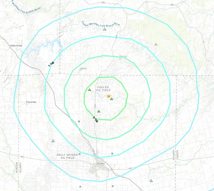
According to the USGS, the epicenter of the 3.5-magnitude earthquake was about 13 miles north of Snyder, in Scurry County (see map above). The recorded depth of the earthquake was five kilometers, or about three miles below ground.
No damage was reported in either Snyder or Scurry County.
The USGS also released an intensity map, which showed some areas in Scurry County and the surrounding area, including Kent County, that reported feeling effects of the earthquake.
The USGS offers the following description for the strength of earthquake magnitude: "Magnitude is expressed in whole numbers and decimal fractions. For example, a magnitude 5.3 is a moderate earthquake, and a 6.3 is a strong earthquake."
In addition to the earthquake in Scurry County, there was a second earthquake reported on Saturday in far West Texas. The 2.8 magnitude earthquake was centered 29 miles west of Mentone. It was recorded at 5:08 p.m. on Saturday afternoon. Mentone is located 77 miles west of Odessa and 22 miles north of Pecos.
As of 9:30 a.m. Sunday morning (November 15th), the USGS had not received any citizen reports concerning the earthquake west of Mentone.
Last Monday (November 9th), a 3.0-magnitude earthquake was recorded about six miles southeast of Gardendale in Ector County. The earthquake hit in eastern Ector County, between the cities of Odessa and Midland at 5:56 a.m.
Map of Ector County Earthquake on November 9th, 2020 (see below):

LOOK: 50 photos of American life in 2020
More From NewsTalk 940 AM


![Earthquake in Nepal Kills at Least 3,600, Death Toll Expected to Rise [PHOTOS, VIDEOS]](http://townsquare.media/site/757/files/2015/04/Nepal1.jpg?w=980&q=75)
![A Total of 11 Earthquakes Hit Dallas Area in 24 Hours [UPDATED]](http://townsquare.media/site/156/files/2015/01/earthquake.jpg?w=980&q=75)